The Beaney Institute - geograph.org.uk - 67732.jpg
From WhereToday
Size of this preview: 450 × 600 pixels. Other resolutions: 180 × 240 pixels | 480 × 640 pixels.
Original file (480 × 640 pixels, file size: 103 KB, MIME type: image/jpeg)
Summary
| Description |
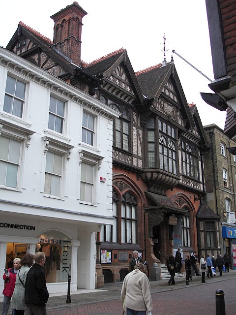
English: The Beaney Institute. Standing in the High Street, opposite the County Hotel, this extravagantly ornate Victorian building was built at the behest of Dr Beaney, the son of a local labourer who made good, became a doctor of medicine, sailed to Australia and became very rich. The building houses the central library and the Royal museum and art gallery. |
| Date | |
| Source | From geograph.org.uk |
| Author | Penny Mayes |
| Attribution (required by the licence) | Penny Mayes / The Beaney Institute / |
| Camera location | | View this and other nearby images on: OpenStreetMap |
|---|
_heading:112.00&language=en-gb)
| Object location | | View this and other nearby images on: OpenStreetMap |
|---|
_heading:112.00&language=en-gb)
Licensing

|
This image was taken from the Geograph GB & Eire project collection. See this photograph's page on the Geograph website for the photographer's contact details. The copyright on this image is owned by Penny Mayes, and is licensed for reuse under the Creative Commons Attribution Share-Alike 2.0 license.
|
This file is licensed under the Creative Commons Attribution-Share Alike 2.0 Generic licence.
Attribution:
Penny Mayes
- You are free:
- to share – to copy, distribute and transmit the work
- to remix – to adapt the work
- Under the following conditions:
- attribution – You must give appropriate credit, provide a link to the licence, and indicate if changes were made. You may do so in any reasonable manner, but not in any way that suggests the licensor endorses you or your use.
- share alike – If you remix, transform, or build upon the material, you must distribute your contributions under the same or compatible licence as the original.
File history
Click on a date/time to view the file as it appeared at that time.
| Date/Time | Thumbnail | Dimensions | User | Comment | |
|---|---|---|---|---|---|
| current | 19:35, 30 January 2010 | | 480 × 640 (103 KB) | wikimediacommons>GeographBot | == {{int:filedesc}} == {{Information |description={{en|1=The Beaney Institute. Standing in the High Street, opposite the County Hotel, this extravagantly ornate Victorian building was built at the behest of Dr Beaney, the son of a local labourer who made |
File usage
There are no pages that use this file.